Saudi Arabia's Communications, Space and Technology Commission announced the winners of its 2026 international non-terrestrial networks research competition on 12 October during the Global Space Connectivity and Sustainability Events in Riyadh. The three winning paper titles address affordable satellite service pricing, commercial aircraft as relays for direct-to-device access, and AI-enabled multi-layer NTN for desert search and rescue. The announcement matters because it connects three questions that production teams often separate: who can afford coverage, which moving infrastructure can carry it, and how decisions are made when connectivity is scarce. It is useful to telecom, satellite, public-safety and digital-product teams evaluating NTN concepts—but a winning research idea is not, by itself, proof of commercial or safety-critical readiness.
The official CST announcement names the papers and reports 81 submissions from 280 researchers and academics, assessed by more than 40 judges. It says first place went to “Affordable Connectivity from the Skies: A Subsidy-Aware Pricing Framework for Satellite Services Under Public Budget Constraints,” second to “Commercial Aircraft as Sustainable Relays for Satellite Direct-to-Device Access,” and third to “AI-Enabled Multi-Layer NTN for Rapid Target Acquisition in Desert Search and Rescue.” Those titles, participation counts and rankings are documented facts from CST. The source does not publish the complete papers, datasets, radio assumptions or independent field results. The architecture and validation guidance below is engineering analysis, not a claim that the winning teams or CST already deployed it.
Why this announcement is timely
The awards were announced during a three-day Riyadh event co-organized by CST and the International Telecommunication Union from 12 to 14 October 2026. The official event page combines the Connecting the World from the Skies forum and Space Sustainability Forum. The ITU programme identifies integrated 6G connectivity, direct-to-device access, WRC-27 preparation, space as critical infrastructure, interference, congestion and orbital sustainability as connected themes.
That grouping is technically important. An NTN product is not only a satellite link. It crosses user equipment, radio access, spectrum rights, satellite or high-altitude platforms, gateways, mobile cores, identity, charging, emergency policy, terrestrial fallback and operations. A concept can improve one layer while moving risk into another. Research evaluation should therefore test the end-to-end service contract, not only peak throughput or model accuracy.
Read the three winners as different system layers
The first-place title focuses on the economic control plane: allocating subsidy under a public budget while preserving service access. The second focuses on a moving network layer: using commercial aircraft as relays for satellite direct-to-device connectivity. The third focuses on an application and decision layer: using onboard or near-edge AI across multiple NTN layers to accelerate target acquisition in desert search and rescue.
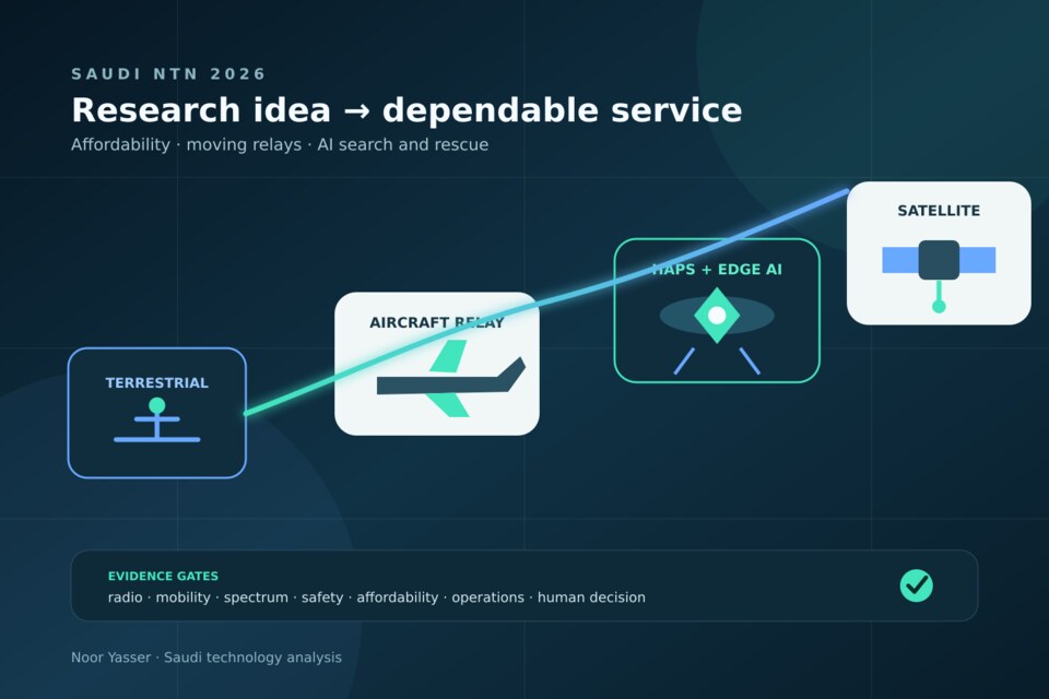
They can be placed in one architecture without pretending they form one implemented system:
User device and distress beacon → terrestrial or D2D radio access → aircraft, HAPS or satellite layer → gateway and mobile core → geospatial event platform → human incident command. Across every hop sit spectrum policy, identity, priority, charging, audit and safety controls.
This model helps reviewers ask the right question at each layer. Affordability policy cannot compensate for an unavailable radio link. An aircraft relay cannot authorize access or prove a rescue target. An AI detector cannot allocate spectrum or replace incident command. Each component needs its own evidence and a clear interface with the next.
Winner one: affordability is a verifiable allocation system
A subsidy-aware pricing framework is more than a cheaper tariff. A production version needs an explicit objective—coverage, eligible households, emergency availability or minimum service quality—and constraints such as budget, geography, capacity and fairness. The allocation engine should operate on auditable inputs, publish explainable rules, and separate eligibility from network admission. Otherwise, a pricing decision can overload a beam or deny service even when the accounting calculation is internally correct.
For an engineering proof, model demand by location and time, link capacity by beam or cell, installation and device costs, expected service class, subsidy source and expiration. Run counterfactuals: what happens when demand doubles, a gateway fails, a region loses terrestrial coverage or a budget is cut? Measure not only average cost but the percentage of eligible users served, service quality by region, denial reasons, unused subsidy, fraud signals and sensitivity to uncertain assumptions.
Do not put sensitive eligibility attributes into the radio path. Issue a short-lived service entitlement from a policy system and let network admission validate the entitlement, class and quota. Keep the underlying personal or financial evidence in a separately governed system. Pricing and subsidy rules must be versioned so an appeal can reconstruct the decision that applied at the time.
The idea is strongest where public-service coverage has a defined target and constrained budget. It is a poor fit when no authority can define eligibility, when capacity is not measurable, or when the model optimizes sign-ups while ignoring usable service. A low headline price without latency, availability and data-volume guarantees is not proof of meaningful connectivity.
Winner two: aircraft relays create a volatile topology
The second-place title proposes commercial aircraft as sustainable relays for satellite D2D access. Without the full paper, it would be wrong to state a specific radio design, frequency, capacity or energy saving. The title nevertheless exposes a useful engineering challenge: aircraft are mobile, scheduled, safety-regulated assets whose position and connectivity change continuously. Treating them as fixed towers would make routing and availability estimates unreliable.
A proof-of-concept needs a time-indexed coverage graph built from permitted flight paths, altitude, antenna pattern, link budget, satellite visibility, Doppler, handover timing and ground demand. It should distinguish safety-critical avionics from the experimental communications payload, define physical and logical isolation, and prove that a payload fault cannot affect aircraft systems. Installation, maintenance, certification, weight, power and airline operational approval are first-class constraints, not rollout details.
The control plane must predict relay availability but tolerate forecast error. A device or network should have a deterministic fallback when an aircraft leaves the geometry, a flight diverts, a satellite handover fails or spectrum cannot be used in a jurisdiction. Sessions need stable identity across relay changes, bounded buffering, replay protection and congestion policy. Emergency traffic may require priority, but priority must be authorized and observable rather than inferred from an application label.
The ITU overview of direct-to-device satellite approaches emphasizes that multiple technical and commercial models exist and that spectrum policy is central. The ITU-R WRC-27 studies identify agenda item 1.13 as studies on possible mobile-satellite allocations for direct connectivity between space stations and IMT user equipment to complement terrestrial coverage. That means a lab link cannot be generalized into an operating right across markets.
Aircraft relays may be worth studying for corridors with regular traffic, sparse terrestrial infrastructure and delay-tolerant or emergency services. They are a weak foundation for a hard availability promise where flight density is low, weather disrupts routes, certification is unresolved or the business depends on one airline. The design should quantify coverage gaps rather than hide them inside an annual average.
Winner three: AI for search and rescue needs evidence, not confidence alone
The third-place title combines AI, multiple NTN layers, HAPS and rapid target acquisition for desert search and rescue. A plausible service might ingest optical, thermal, radio or geospatial observations near a high-altitude platform, rank candidate targets and send compact alerts over a constrained link. That can reduce the amount of raw data crossing an intermittent network. But the announcement does not disclose the model, sensors, training set, accuracy or field validation, so none should be assumed.
A safe architecture keeps detection separate from rescue authorization. The edge model emits a candidate with time, coordinates, sensor provenance, model version, uncertainty and a small evidence package. A geospatial service deduplicates observations, checks terrain and search boundaries, and correlates them with other sources. A trained human confirms tasking according to incident policy. The system records why a target was accepted, rejected or revisited.
Evaluate by operational strata, not one aggregate score: day and night, dust, heat, different terrain, partial occlusion, sensor degradation, altitude and communication loss. Measure recall for real targets, false alerts per search hour or square kilometre, localization error, time to first useful alert, evidence-transfer size, energy use, dropped-event recovery and human review time. A model with high offline accuracy can still make operations worse if it floods responders with false candidates or fails silently outside its training conditions.
Onboard inference should degrade predictably. If the model cannot run, the platform may switch to rules, lower-resolution sampling or delayed bulk transfer. Never report an empty result as “no target” when the sensor, model or link failed. Health state and search result are different fields. Retain signed model and configuration versions, secure updates, rollback and a bounded offline mode.
This approach is most promising when bandwidth is scarce, early filtering saves time and responders can review evidence. It should not be the sole locator for life-critical decisions, a substitute for trained search teams, or a surveillance system without legal purpose limits, retention rules and access controls.
A shared validation ladder
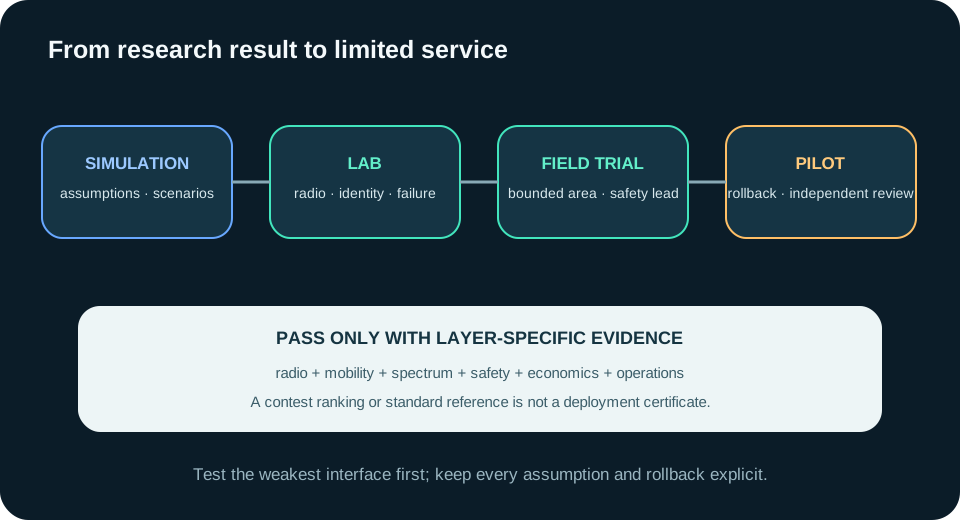
All three ideas benefit from the same staged evidence model. First, reproduce the concept in simulation with documented assumptions. Second, validate each layer in a controlled lab: radio, mobility, allocation logic, sensor model, identity and failure handling. Third, run a bounded field trial with synthetic or consented data, restricted geography and a human safety operator. Fourth, conduct an operational pilot with rollback, incident reporting and independent review. Only then should a team consider a limited service launch.
At every stage, maintain an assumption register. Record spectrum authorization, device capability, satellite or HAPS availability, aircraft participation, capacity, weather, model dataset, subsidy budget and human staffing. An assumption becoming false should stop or narrow the trial automatically. Research maturity is not a single readiness score; the radio, safety, policy, business and operations tracks can be at different levels.
Standards are a baseline, not a deployment certificate
3GPP's official Release 17 NTN work item documents solutions for NR support of non-terrestrial networks. Standards help devices and networks agree on interfaces and behavior. They do not prove that a particular satellite constellation, aircraft payload, HAPS platform, pricing policy or AI model meets a product's availability, safety or regulatory target.
Build a compliance matrix that maps each service requirement to a standard clause, regulator approval, test result and owner. Keep vendor claims separate from witnessed tests. Include coexistence and interference, lawful access, emergency calling, roaming, security keys, data residency, accessibility, billing disputes, incident response and decommissioning. NTN crosses more institutional boundaries than a conventional software feature; unowned interfaces become operational failures.
Product and developer impact
For product teams, the announcement suggests that meaningful connectivity is a portfolio problem. A roadmap must combine coverage, affordability and useful applications rather than optimize one metric. Define the user promise precisely: message delivery, periodic telemetry, emergency alert or broadband session. Each promise implies a different latency, power, capacity and fallback contract.
For developers, design asynchronous workflows. Connectivity may arrive in windows, acknowledgements may be delayed and the same event may be replayed through another path. Use globally unique event IDs, idempotent consumers, monotonic state transitions, expiry, compact evidence bundles and explicit delivery state. Keep device time uncertainty and location accuracy in the data model.
For operators, observe the end-to-end path: access attempt, selected layer, handover, congestion decision, gateway, core transaction, application acknowledgement and user-visible result. Aggregate metrics can hide regional dead zones. Slice availability and latency by geography, service class, device, relay type and failure cause while applying privacy controls.
Best practices and anti-patterns
Start with one bounded service and geography. Publish the assumptions and exit criteria. Separate research claims, provider claims and independently observed results. Test loss of each relay and gateway. Budget for certification, spectrum coordination, safety review and long-term operations. Give users an honest delivery state and a terrestrial fallback where possible.
Avoid calling a simulation “coverage,” a contest ranking “production validation,” or a standards reference “regulatory approval.” Do not use annual averages to hide outage windows. Do not let an AI confidence score trigger an irreversible rescue or surveillance action by itself. Do not promise affordability without specifying who qualifies, what service is delivered and how capacity is protected.
Executive takeaway
The Saudi NTN 2026 winners are valuable because they broaden the engineering conversation beyond satellite throughput. One asks how service is allocated fairly, one explores a new moving relay layer, and one moves intelligence closer to a time-critical mission. CST's announcement establishes the winners and their high-level topics; it does not establish commercial, safety or field performance.
The responsible next step is to turn each idea into a falsifiable service contract. Specify the user promise, radio and mobility assumptions, policy authority, safety boundary, evidence, failure modes and rollback. Then test the weakest interface first. Non-terrestrial networks become useful infrastructure when every layer—from affordability to orbit to human decision—can be measured and challenged.
Official references
These references document the tools discussed. Examples and design decisions are illustrative and should be adapted to the project and its versions.
- CST — Winners of the NTN 2026 International Research Competition, published 12 October 2026
- CST — Global Space Connectivity and Sustainability 2026, event dates 12–14 October 2026
- ITU — Global Space Connectivity and Sustainability Events 2026, verified 13 October 2026
- ITU-R — Preparatory studies for WRC-27, including agenda item 1.13, verified 13 October 2026
- 3GPP — Release 17 work item: solutions for NR to support non-terrestrial networks, verified 13 October 2026
- ITU — Direct-to-device satellites: four ways to connect the world, published March 2026
Prepared by: Noor Yasser
Working through a similar engineering challenge?
I help teams turn architecture decisions into a clear scope and dependable, reviewable implementation.